
09 March 2026
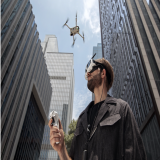
I’m Jim Peterson, an FAA Part 107-certified drone pilot based in Indianapolis, Indiana. I fly commercial drone missions within about a 35-mile radius of Indianapolis, focused on one thing: giving construction teams clear, consistent progress visibility they can actually use. If you need repeatable site documentation, orthomosaic mapping, and organized progress photo sets delivered fast, that is my lane.
Before drones became my day-to-day work, I spent years as a high school theatre and film teacher. That might sound like an odd origin story for construction progression drone services, but it makes perfect sense once you see how I work. Teaching film trained me to plan shots, think in sequences, and capture visuals that communicate, not just visuals that look cool. Teaching theatre trained me to be calm under pressure, run a process, and deliver on a deadline. Those are the same skills that matter when you are flying near active work zones, coordinating with schedules, and turning raw images into clean deliverables that help a project manager answer questions quickly.
I’ve always had two strong interests running side by side: the creative pull of film and the technical pull of science and technology. I was the kind of teacher who loved storytelling but also loved the gear, the systems, and the “how it works” side of things. My left-brain tendency shows up in the way I approach drone work now. I like repeatable workflows. I like consistency. I like standards. I like a clean handoff at the end where a client can open a folder and immediately understand what they’re looking at.
That is why construction progression became such a natural fit for me. Construction is a world of moving parts: multiple trades, changing conditions, tight timelines, and teams who cannot always be on-site. The biggest problem I see over and over is not a lack of photos. It’s a lack of useful photos. A random batch of images from random angles makes it hard to compare week to week. It creates more questions than answers. My goal is to remove that friction by delivering progress visuals that are consistent, clearly labeled, and easy to interpret.
How I became a licensed drone pilot
I earned my Part 107 certification in December 2023 and passed the exam on the first try. I studied using a mix of YouTube videos and structured online training through Drone Launch Academy. That training process did two things for me. First, it gave me the technical foundation to operate legally and responsibly in the National Airspace System. Second, it sparked a genuine interest in aviation itself. Once you start learning airspace, weather, sectional charts, and decision-making, you realize how much is going on above your head every day. I didn’t just study to pass a test. I studied because I wanted to be a professional, and I wanted every flight to be deliberate.
Becoming a Part 107 pilot also felt like a turning point personally. I’ve always loved film, and the idea that I could pilot a flying camera was, frankly, amazing. The first time you see a scene from above that you could never capture from the ground, it changes how you think about visual communication. Drones are not just a camera on a stick. They are perspective, context, and scale. They help people understand a space in a way that maps, texts, and quick phone photos often cannot.
What I do today: construction progression documentation that stays consistent
My work is centered on construction progression, specifically orthomosaics and progress photo sets. These two deliverables work together beautifully.
Orthomosaic mapping gives you a high-resolution, top-down “whole site” view. It’s useful for tracking overall progress, verifying layout and staging, and giving stakeholders a single image that makes sense instantly. A good orthomosaic becomes a visual record you can reference later. It’s also a practical tool for reporting because it reduces miscommunication. Instead of trying to describe what changed, you can point to what changed.
Progress photo sets give you consistent viewpoints that make comparisons easy. I’m a big believer in repeatability: the same angles, the same general framing, and the same intent each visit. When you capture progress this way, the changes jump out. Stakeholders do not have to guess. Project managers do not have to explain as much. Owners and remote teams can see the story clearly.
My standard turnaround is 72 hours. That matters because progress documentation only helps if it arrives while it’s still relevant. Whether you’re preparing for an internal update, a stakeholder report, or just trying to keep everyone aligned between site visits, predictable delivery is part of the service, not a bonus.
The gear I fly and why it matters
I fly tools selected for the job, not for bragging rights:
-
DJI Mavic 3 Enterprise with RTK for precision capture and mapping workflows. RTK support is a major advantage when you care about repeatability and accuracy.
-
DJI Air 3 for aerial photos and video when you need strong visual coverage, clean footage, and flexible capture.
-
DJI NEO for interior or close-up work where a smaller footprint helps, or where you need tight, controlled movement in closer spaces.
Hardware matters, but process matters more. The real difference is how you plan the mission, capture the data, and deliver it in a way that a construction team can use without extra work.
My workflow: predictable, organized, and built for real-world use
Clients usually want the same core things from a construction progression drone pilot:
Consistency: “Show me the same views every time so I can compare progress.”
Clarity: “Label it so I don’t have to guess what I’m looking at.”
Speed: “Get it back to me quickly so it’s useful.”
Professionalism: “Be safe, be reliable, and don’t create problems.”
That’s the standard I hold myself to. I plan flights with safety and efficiency in mind, capture imagery intentionally, and deliver clean file structures so you can find what you need quickly. When clients tell me they are juggling multiple active sites, what they’re really saying is: “Make this easy for me.” My deliverables are designed to do exactly that.
A quick story that shaped how I work with clients
My first paid job as an aerial photographer was a night flight documenting the lighting of a parking lot. The shopping area was divided into sections, and the client needed orbit videos, multiple photos, and approach shots. I remember being hyper-vigilant because it was my first job and I was flying at night. I had multiple lights mounted on my (then) new Air 3, and I was focused on doing everything correctly.
Then, I ran into a problem that taught me a lesson I still carry today: miscommunication through a middle-man. The client and the provider coordinating the job hadn’t mentioned lights at the back of the commercial properties. So even though my flight went well and the footage looked great, I had to go back and re-fly the mission to capture what the end client actually needed. The provider ended up showcasing the video on their website, which was a nice compliment, but the bigger takeaway for me was operational: good drone work is not just flying. It’s clarity up front, understanding deliverables, and making sure everyone is aligned before props spin.
That experience pushed me even harder toward my current approach: ask the right questions, define the deliverables, then execute with consistency. That’s how you avoid rework, protect schedules, and deliver results that feel smooth and professional.
Why clients hire me
If you’re using this platform to find a drone pilot, you probably have options. Here’s what I think makes my work stand out for construction progression clients in Indianapolis and the surrounding area:
-
I’m built for repeatable progress documentation. Same viewpoints, consistent framing, and deliverables designed for comparisons.
-
I understand the value of orthomosaics and structured reporting. Not just pretty aerials, but useful visuals that answer questions.
-
I deliver quickly. My standard turnaround is 72 hours because speed is part of the job.
-
I’m both technical and visual. I can capture mapping-ready image sets and also produce clean aerial video with editing.
-
I communicate clearly. Teaching trained me to explain, simplify, and deliver with a process.
If your team is tired of chasing updates, struggling to show change over time, or relying on inconsistent photos taken from the ground, consistent aerial progress documentation can tighten communication fast. My goal is to make your updates easier to produce, easier to understand, and easier to share.
Service area and best-fit projects
I’m based in Indianapolis, IN and typically serve clients within roughly 35 miles. My best-fit work is construction progression, especially projects that benefit from recurring documentation: residential development, commercial sites, multi-phase builds, and any job where stakeholders need a clear visual record without constant site visits.
If you need orthomosaics, progress photo sets, or aerial video updates that are consistent and organized, reach out through thedroningcompany.com and tell me what you’re tracking, how often you need updates, and what your ideal deliverable looks like. I’ll help you choose a straightforward approach that fits your schedule and your reporting needs.
WATCH