
By Bill King @portsidesurvey
Aerial surveying is changing the way a variety of construction projects are surveyed and managed. In this article, I will share some of my experiences with the evolution of aerial survey—where it is today, a brief description of aerial surveying and photogrammetry, how it works, and what equipment and expertise are required for aerial surveys. I will also give an example of how aerial survey changed the way a $1.5-billion-dollar project was surveyed and managed.
Photogrammetry is defined by the American Society for Photogrammetry and remote sensing (ASPRS) as “the art, science, and technology of obtaining reliable information about physical objects and the environment through processes of recording, measuring, and interpreting imagery and digital representations of energy patterns derived from non-contact sensor systems."
In simpler terms, photogrammetry is making three-dimensional measurements by taking overlapping photos, which are used to triangulate the positions. It's much the same idea as your two eyes being able to have depth perception, but if you cover up one eye, you lack that depth perception. The terms “aerial survey” and "photogrammetry" are often used interchangeably. I would argue that using the term "aerial survey" implies a level of expertise and licensure in the field of surveying.
I started my journey with aerial survey 20 years ago. At the time, I was working for a land survey and civil-engineering firm. One of our clients was an aerial-survey firm. Back then, an aerial survey was an expensive proposition. Our company would be tasked with setting the ground-control points (GCPs) for flights. We usually had a two-man survey crew on the ground for a full day of setting aerial targets that had to be an exact dimension—usually 1' wide and 6' by 6' crosses. We would run a traverse loop using a total station through all the aerial targets and survey monuments to accurately measure the locations of the targets. Our client would fly the project in a plane and shoot photos on film.
The process after that was a nightmare.
It involved manually lining up developed film, viewing via stereoscope, and hand-drawing contours that best case scenarios were accurate to 1' vertically and 0.50' horizontally.
Let's fast forward to today, where absolutely amazing advances in technology have dramatically changed the game. You have affordable drones such as the Phantom 4 Pro Version 2 which is capable of producing a photogrammetry product relatively accurate to about 0.15' vertically and half that horizontally. Many of the old sources of error in photogrammetry have been eliminated. Drones like the Phantom 4 Pro RTK and eBee Plus have survey-grade RTK GPS built-in, that, in theory, could be used to produce an accurate map with no GCPs at all. Although I wouldn't ever recommend that approach. In my experience, you always need to have plenty of GCPs and checkpoints that were not used to shape your final products.
I started doing drone surveys in 2017. I have now completed around 600 drone surveys. I have access to quite a few drones at my work, including a Matrice 200 with an X4s camera, Inspire 2 with X4s camera, eBee Plus RTK, Phantom 4 Pro Version 2, Phantom 4 Pro RTK, and Parrot Anafi. We usually use PIX4dcapture for flight planning, and Pix4d mapper for processing our photogrammetry data.
My workhorse drone is the Phantom 4 Pro Version 2. Its 1" sensor and mechanical camera shutter make it ideal for accurate photogrammetry survey. I've found flying the survey at 150' above ground level with 75 percent sidelap and forelap is the sweet spot for accuracy without taking so many pictures as to make processing ridiculous—even with a super computer.
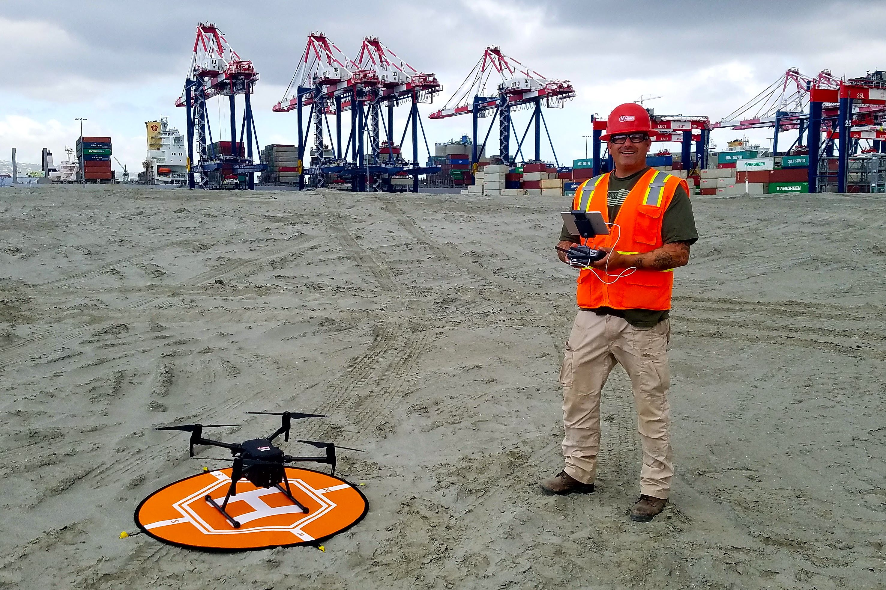
I have been fortunate to work for a construction company the last 11 years that is very supportive of our survey department. They are more than willing to invest in the latest and greatest technologies. More often than not, those investments quickly pay for themselves, as in the example of the Port of Long Beach's Middle Harbor Redevelopment Project—a ten-year, $1.5 billion project.
WATCH! Long Beach Container Terminal at the Port of Long Beach Now Complete
This project took 50 acres that were almost 50 feet deep, and did a 90-foot fill for a surcharge at elevation 40, before removing that material back down to a finished grade varying between 12' and 15'. We moved five-million yards of material, and much of that material was moved more than once, and had to be tracked accurately for payments. This presented some serious challenges—including the safety of a surveyor trying to track volumes of material that is equal parts underwater, mud, and firm walkable material.
In the beginning of the project, we didn't have the drone survey in our tool kit, and it made for some difficult and dangerous surveying to get data in the regions where freshly dredged material had been pumped into an area, as well as the border areas of mud with water. The underwater surveys were performed throughout the project using multibeam sonar, and where conditions did not allow for that, single-beam low-frequency sonar or even lead lines.
When we made new land, it was often in the tidal zone and very unstable. I would walk out with a GPS rover taking topographic shots until I would start sinking in the mud—at which point, I would work my way back and try to shoot another section. Then, you would have to interpolate the gap in data between your hydro data and your land shots.
In late 2017, we started using a drone to survey. At first, we didn't trust the accuracy of the data, so we went through great lengths QC-ing our results with traditional land-survey methods. This allowed us to get data in the areas that were too dangerous to collect using traditional survey methods.
It also allowed a survey of the entire 150-acre jobsite to be collected in about 40 minutes. A topographic survey of the area would have taken about two days to collect.
I was creating weekly point clouds and orthomosaics with job backgrounds overlaid of the entire 150-acre jobsite. After several months of this with the port surveyors and subcontractors independently checking my drone data versus their data collected with traditional land-survey techniques the entire project began to lean on my drone surveys. Subcontractors and the client allowed for payment based on my survey data from the drone. The entire project used my orthomosaics and point clouds to track progress and plan workflows. On this one project alone, I did more than 300 drone surveys, quickly providing products that can't be replicated with traditional-survey methods to an accuracy that met or exceeded the client's expectations.
We found that the drones volumes were actually more accurate than traditional surveys because the point cloud is so dense. The drone vertical data may only be accurate to 0.15' versus the RTK GPS shots vertical accuracy of 0.05', but with the drone, you were capturing everything quickly—every little rock, variations in slopes, etc. Whereas with a traditional topo land survey, you are generally shooting a 50' grid tops and toes of slope, and interpolating a surface based on those shots losing quite a bit in real changes in the surfaces.
In summary, drone aerial survey has been an amazing addition to the surveyor's tool kit. It is a quick, safe, and affordable way to provide clients and project managers with valuable and accurate survey information. I have been amazed at the repeatable accuracy I have been able to perform.
Drones are changing the game for surveys both large and small, as well as the type of deliverables that can be provided. I look forward to what the future has in store as drone LIDAR systems become more affordable, and photogrammetry software improves. The sky's the limit.