
By Juan Irache, Telemetry Overlay
Telemetry Overlay is an easy, all-in-one way to create a heads-up display for your action videos and drone footage. The app is compatible with multiple camera brands and data formats, including GoPro, DJI, Insta360, Garmin, and GPX. You can merge consecutive videos with GPS data, sync the telemetry of multiple sources, customize your gauges, and much more. In the past two years of working with drone operators, I've discovered that these "data-enabled videos" have interesting use cases that go beyond what my company was initially conceived for.
Let's explore some of them.
But first, what are data-enabled videos?
Most modern aerial vehicles that record video also record a stream of telemetry data—a flight log. This usually includes information such as the GPS coordinates, orientation, battery levels, flight mode, error messages, camera settings, and sometimes much more. For example, DJI drones store these streams in the controlling device (often a smartphone), but also save a simplified version as video subtitles in the SD card alongside the video files or within them. Other brands like Autel or Parrot make the logs accessible to third-party apps and services. Visualizing the recorded data in sync with the video enables a range of use cases that can benefit both professional and amateur operators.
Accident Analysis
Most drone operators have experienced an in-flight incident. The first two concerns when that happens are: Is anyone hurt? And then, is the drone retrievable? (And if so, in how many pieces?)
But then in the longer term, two important questions arise: What caused the incident, and how can we prevent it in the future. Flight logs exist for this very reason. Great tools like AirData.com and PhantomHelp.com allow us to retrieve the flight data and visualize it for analysis, but comparing the video footage to the logs can provide very relevant context and make the analysis much more understandable and user friendly.
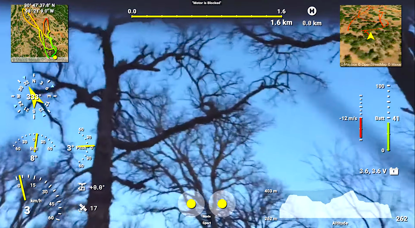
Here's a quick case study from a DJI Mini2. Thirty-four seconds into the footage below, we can see how the drone yaws (rotates) to the left. However, that is not reflected in the data, as the heading (compass) gauge indicates. This seems to point to an IMU (Inertial Measurement Unit—basically an accelerometer and a gyroscope) malfunction. As a result, the drone does not know which direction it is looking. Immediately after, it starts shaking, and at 43 seconds, it starts moving slightly backward, and then to the left. The GPS data is still correct at that point, based on the number of satellites, and it shows the drone is moving east and then south. Why? The aircraft it's trying to hold its position, but as it does not know which direction it is facing, it makes corrections in the wrong direction, making the problem worse, until it eventually crashes with the trees. In this case, the analysis could exonerate the pilot and grant them a replacement unit.
Training
You might have watched drone training videos where the operator has a second camera pointing at their thumbsticks to show how every maneuver is performed. Why do that when you can integrate the thumbstick positions visually into the video?
Not only that. You can display a range of gauges to demonstrate things such as the correlation between pitch and roll and movement, safe operating battery and voltage levels, techniques for understanding the orientation of the drone, best practices regarding altitude, how radio control signal degrades with distance and obstacles, movement perception with stabilized video streams compared to actual attitude, optimal camera settings for cinematic results, and so much more depending on your field of expertise.
This is especially appealing for FPV flight training, due to the high skill level required, but also for training at any level. Students can be easily tricked into thinking they are in control of the aircraft if they do not know the clues they should pay attention to.
Surveillance
Professional drone operators often offer surveillance or inspection services. From road maintenance work to electric-line scrutiny or roof examination, having supporting data in addition to the video footage can be crucial when it comes to analyzing and classifying the work done. For this use case, operators often need to answer questions such as: At what coordinates are those road bumps located? Which orientation is the damaged equipment facing? How far from the station is a given construction? What altitude is needed for clearing the tower? Did the flight path go according to plan? How does this terrain look from a satellite photo compared to visually? And so on. Having data-enabled videos in your tool set can help answer these questions and raise the bar for competitors. Also, it just looks cool on your portfolio.
Show off
Flight data is also useful for highlighting your skills as a pilot. You can show how far you traveled with distance and home-distance gauges. FPV pilots can prove their high speeds with a speedometer or speed vs. time gauges. Acrobatic drones will record full 360 pitch-and-roll values that can be displayed as an airplane attitude indicator. You can give your videos a professional high-tech look by styling a wide range of gauges. Batteries can be put to the test by overlaying flight duration times and voltage levels. The list of ideas goes on...
More
Of course, drones are not the only devices that record interesting sensor values. Action cameras such as GoPro or Insta360 can embed GPS and accelerometer data into their videos. Full-scale plane instruments have very accurate flight logging. Activity trackers read and compute complex activity-specific analytics such as cycling, karting, sailing, or motorcycling. Increasingly more tech brands (including Tesla and Aprilia) are enhancing their products with data-logging capabilities. And every one of us can record data-enabled videos with the GPS-enabled camera we carry in our pockets.
WATCH: A LOOK AT TELEMETRY OVERLAY