
22 November 2022
By Brad Schmidt
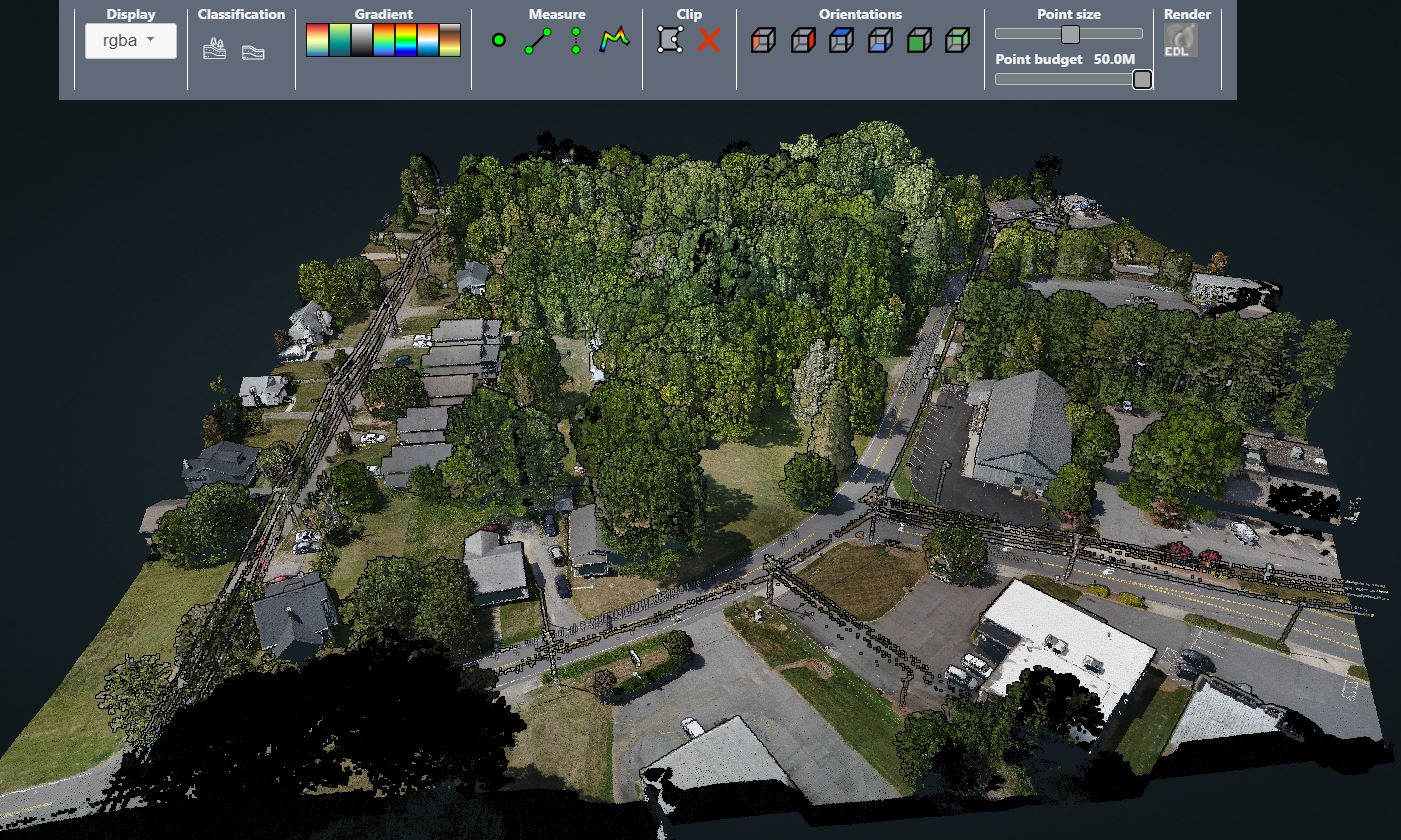
Collecting imagery with uncrewed aerial vehicles (UAVs) is ideal for a variety of applications, including topographic mapping, forestry ground and canopy measurements, powerline corridor mapping, Digital Terrain Model (DTM) generation, high-resolution digital imagery, and orthophoto production, along with support for a variety of other mapping needs.
Historically, aerial surveys were performed only by large, crewed aircraft and not UAVs, due to the size-weight and power constraints of the professional sensor payloads that made them impossible for use on the smaller aircraft. Additionally, it was a challenge for the earlier UAVs carrying basic cameras to meet the requirements for measuring position and orientation with a high enough degree of accuracy to support surveying and mapping requirements, for example when georeferencing a point cloud data set. This meant a network of ground control points needed to be established for georeferencing, greatly increasing the cost.
Developments in the UAV Industry
The most rapid development taking place in the UAV industry today is the dramatic improvements witnessed in new and improved GNSS/inertial for direct georeferencing (DG) and imaging sensors purpose built for mapping and surveying from UAV’s.
Red, green and blue (RGB) cameras, for example, are continually evolving to hold smaller and lighter form factors, while seeing ongoing improvements in resolution and image quality. Some of these payloads, such as Phase One’s iXM 50 and 100 MP cameras are producing results superior to previous generations of medium-format metric sensors being flown onboard crewed aircraft.
Similarly, LiDAR sensors continue to improve with smaller more powerful point-cloud imaging systems. High end, compact, professional mapping LiDARs such as those available from Riegl, YellowScan, and Teledyne Optech, are designed specifically for UAV platforms.
These imaging sensors are integrated with next generation, miniaturized yet full featured GNSS/inertial systems for DG, and can achieve survey-grade accuracy without the use of ground control points. Furthermore, LiDAR systems are now being combined with RGB cameras to produce true color point clouds as the ultimate UAV surveying payload.
All of these advancements can be expertly combined to produce results to meet project requirements including accuracy, cost, and usability.
Delivering Cost-Efficient, Survey-Grade Data
Surveyors tasked with collecting and analyzing data from the field can face a myriad of challenges. From inclement weather to uneven terrain, paired with the added inefficiencies of inputting and then analyzing data, a standard survey project can easily extend to several days of work.
Utilizing a UAV to survey an area can be an alternative option to avoid demanding environments in the field. Microdrones, a leader in drone LiDAR and photogrammetry surveying equipment and software for geospatial collection and processing, was challenged to deliver point-cloud data according to updated survey grade standards.
LiDAR sensors continue to improve with smaller and more powerful point-cloud imaging systems.
Microdrones found a solution by adding high accuracy DG of LiDAR data to their technology stack. DG directly measures the position and orientation of an airborne mapping sensor, such as a digital camera or a laser scanner. This makes it possible to assign a geographical location on the earth to a pixel from a camera image or a digital point from a laser without the need for any ground points or additional measurements referencing the ground. For this level of accuracy, Microdrones turned to Applanix, a Trimble company. As a prerequisite to implementation, Applanix needed to meet specific requirements to reduce the weight of the hardware, while keeping the accuracy and performance of the inertial measurement unit (IMU).
This integration of hardware and software solutions offered cost and time efficiencies in mobile mapping with UAVs. Microdrones could provide their geospatial customers with a fully integrated system to rapidly capture accurate LiDAR data for surveying, mining, construction, oil and gas, and precision agriculture industries. A simplified workflow involves flying the drone, uploading the data to the cloud for processing, and then downloading the final processed data—thus making it possible for users to access the most accurate and simplified georeferencing data available via post-mission production. A quick, uncomplicated and inexpensive turnkey solution like this can make it easier and more affordable for surveyors to have access to everything needed for complex surveying work.
Safety When Surveying in Hazardous Conditions
Several scenarios exist where the risk posed to a survey crew is significant. One such example is seen in a section of limestone cliffs in France where the natural degradation can generate landslides and falling debris, threatening the land, roads, and people beneath.
Without the ability to map and accurately assess the stability of land formations, the management of this risk currently relies primarily on trajectory analysis. This consists of simulating falling rock masses from ridges to the valley floor, using calculations that consider the size, energy and shape of the material. While this allows for some risk assessment, detailed and correct maps based on high-resolution UAV LiDAR DTM and integrity analysis is required for complete risk analysis.
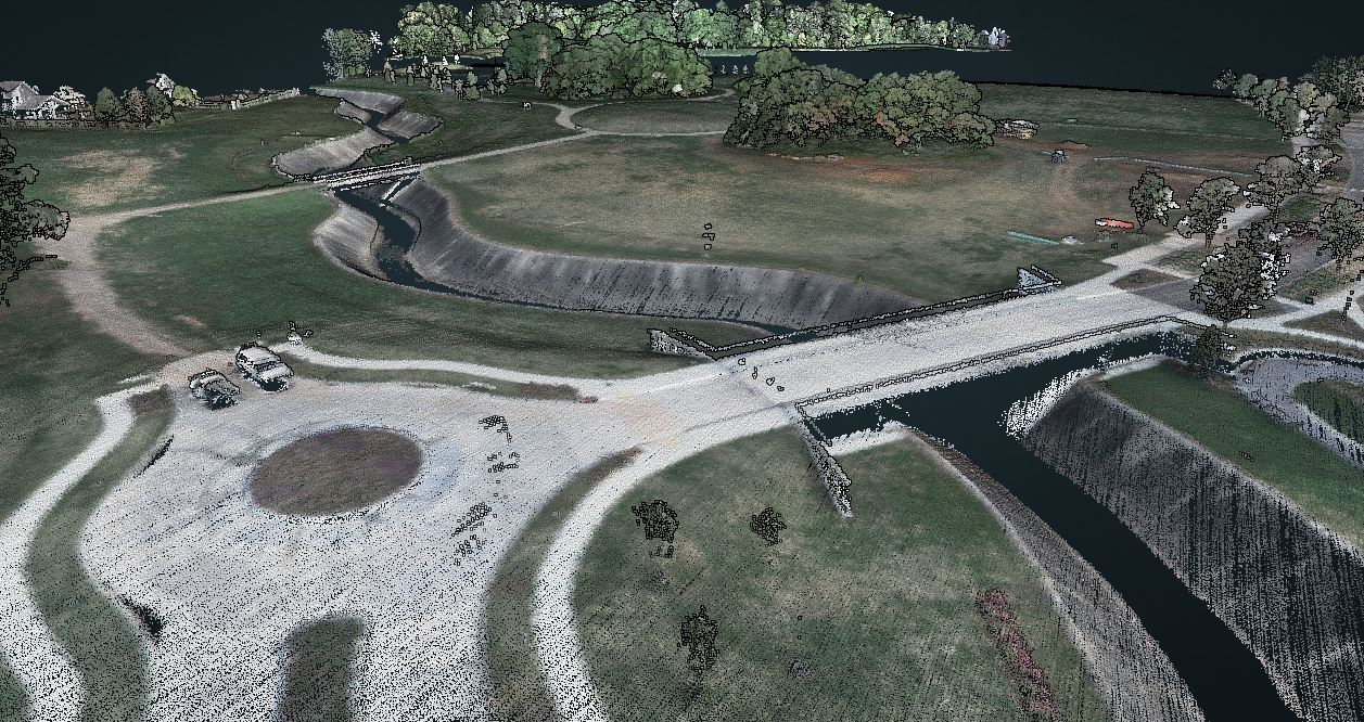
The configuration and the hazardous nature of the limestone terrain does not allow for crews to operate traditional survey equipment on the ground. Using a UAV LiDAR system enables the rapid generation of cost-effective, accurate DTM and 3D products. In addition, the data can be captured safely in what would be otherwise considered an unreachable area, along with the ability to perform repeat monitoring. This is exactly what L’Avion Jaune did when equipping its Multirotor M600 with the YellowScan VX-20 and Applanix APX-20 UAV to map the cliffs in France.
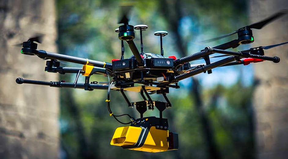
L'Avion Jaune Multirotor M600 drone.
L’Avion Jaune flew four flights of 15 minutes each to map the entire project area over two days. This operation was carried out at sunrise when the road had little traffic. Checkpoints were then surveyed with differential GPS. The data processing involved computation of georeferenced trajectory, matching flight lines, and point cloud classification.
This allowed L’Avion Jaune to optimize the choice of material and work with best practices to collect and process LiDAR data required for high-accuracy mapping in dense vegetation. The flexible UAV deployment of resources allowed the acquisition of dense point clouds (100 pts / m²) and the generation of a precise and exhaustive DTM. The generation of a 3D model of the cliffs that were overhanging a frequented road was essential for the safety of traffic and people below. The site footprint modeled by the YellowScan VX-20 with Applanix DG inside was 200m high, 300m wide, and 2.5 km long, resulting in a high degree of precision without exposing crews to danger.
Modern Day UAV Mapping
Impacting everything from how roads are built to extinguishing forest fires to managing the efficient growth of crops, UAVs deliver important information that can be difficult to obtain otherwise. And, today’s technology is making it possible to achieve far superior results to other technologies in mapping and surveying. Using methods like DG combined with multiple sensor integrations, professional survey-grade aerial mapping systems for UAVs are becoming more widely available. This uncomplicated and inexpensive solution is not only practical in the ability to combine light weight equipment specifically designed for airborne hardware, but also more affordable for companies of any size wanting to take on more challenging mobile mapping projects.
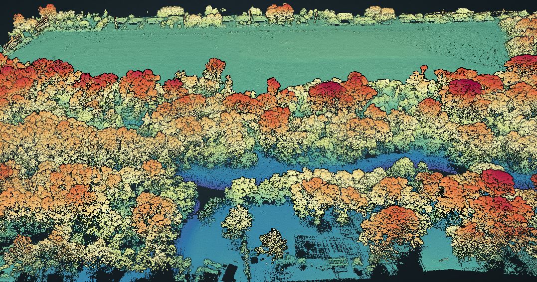
Tree canopy.
About the Author
Brad Schmidt is the global sales manager of the UAV business segment at Applanix, a Trimble company. He has more than 30 years experience in the geomatics, remote sensing, UAV and infrastructure industries. Schmidt holds a Master of Science degree in Physical Geography, with specialization in remote sensing and the geosciences. This article was originally published in the November 2022 issue of xyHt.